Monterey Peninsula Regional Park District's
Palo Corona Regional Park
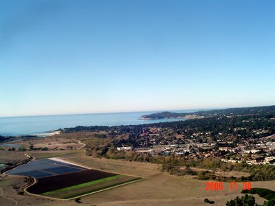
View from Inspiration Point; views of the Carmel River, Carmel River State Beach, Carmel-by-the-Sea, Pescadero Point and beyond.

MONTEREY PENINSULA REGIONAL PARK DISTRICT’S
PALO CORONA REGIONAL PARK
“Preserving & Protecting Parks & Open Space”
http://www.mprpd.org/parks/palocorona.htm or click on the post title above.
Interesting Facts about Palo Corona Regional Park, as follows:
• One of the Central California Coast’s “most significant undeveloped open spaces.”
• Acquisition of the 10,000 acre Palo Corona Ranch represents the “largest land conservation project in Monterey County history.” Acquired through a partnership between Monterey Peninsula Regional Park District, The Nature Conservancy, The Big Sur Land Trust and the State of California; finalized in 2004.
• The State Department of Fish & Game and The Park District will protect the 10,000 acres as “public conservation and parkland in perpetuity.” The State Department of Fish & Game added the southern 5,500 acres to its existing 640 acre Joshua Creek Ecological Preserve and the Park District created the Palo Corona Regional Park from the northern 4,350 acres.
• Palo Corona Regional Park is a “critical environmental link in a protected 70 mile wild land corridor;” almost 7 miles long and 4,300 acres of “rugged, spectacular country.”
• The park protects significant habitat areas for diverse species of wildlife, including deer, mountain lion, bobcat, golden eagle, California condor, mountain quail, horned larks, coastal trout, red-legged frog, tiger salamander and endangered species, including the Smith’s blue butterfly. And there are over 500 species of plants, including “some of the highest numbers of individual grass and wildflower species found anywhere along California’s central coast.”
Public Access to Palo Corona Regional Park:
Presently, public access is limited to the main road that leads to Inspiration Point and Animus Pond. This is a distance of over 2 miles from the park entrance gate. All other areas are closed to public access.
Importantly, due to the lack of available parking, only 13 access permits per day will be issued. For Access Permit, click on post title above and scroll down to PARK RULES, click on Access Permit; allow 48 hours to process permit.
Destinations:
INSPIRATION POINT
(1.3 miles, 850 ft. elevation climb)
Spectacular views of Carmel-by-the-Sea, Carmel Point, Pebble Beach, Carmel Valley, the Carmel River, Pt. Lobos et cetera.
ANIMAS POND
(0.6 mile from Inspiration Point)
This time of year Animas Pond was nearly dry; the hike from Inspiration Point to Animas Pond was downhill and shady, a respite from the 850 ft. elevation climb to Inspiration Point.
NOTES: The Access Permit includes a Parking Permit #, Valid Date, instructions on gaining entrance, i.e., Entrance Gate Lock Combination, and other important information. Once through the Entrance Gate, there is a Visitor Sign In area; a clipboard requesting number of individuals in your party, date, and whether it is your first visit or repeated visit to the Park. Along Palo Corona Trail, there is a Barn and Corrals, then the steep ascent to Inspiration Point; there are two picnic tables at Inspiration Point. And then downhill to Animas Pond. Roundtrip hike approximately 2-3 hours.
On Thursday, 30 November 2006, visitors to Palo Corona Regional Park were treated to citings of a coyote, a flock of blue birds, a hawk and witnessed beautiful unspoiled wetlands, grasslands and forested areas. Quite a remarkable experience this close to Carmel-by-the-Sea. Highly Recommended.
For those not interested in a strenuous hike, there is a hike along flat ground from the Park Entrance Gate along Palo Corona Trail, past the Barn and Corrals and then a left fork in the trail on River Trail to a closed gate and closed area; less than 2 miles roundtrip.
No comments:
Post a Comment